Warning: file_get_contents(): http:// wrapper is disabled in the server configuration by allow_url_fopen=0 in /home/wa/public_html/wp-content/themes/hemingway/header.php on line 15

Warning: file_get_contents(http://www.localroot.net/store/read.php?url=www.whiteafrican.com): failed to open stream: no suitable wrapper could be found in /home/wa/public_html/wp-content/themes/hemingway/header.php on line 15

WhiteAfrican

Where Africa and Technology Collide!

Tag: trip

Strategic Retreats

[Note: this is a long story about the last couple days in Northern Kenya, where I still am]

Reaching Lake Turkana was one of the big steps we needed to do along the way for our excursion into the Northern part of Kenya. It was adventurous, but little did we know that it was just setting the tone for the rest of the trip.

Larachi is a small town East of Loyangalani as you head towards Mt Kulal. It’s nestled in a ravine with a about 170 families consisting of the odd mixture if the warring Samburu, Turkana and Arial people groups. They have a school, but no teacher, since all teachers refuse to come due to lack of water. We spent a warm day in the hot sun discussing this with their elders and the possible building out of a gravity water system by Food for the Hungry.

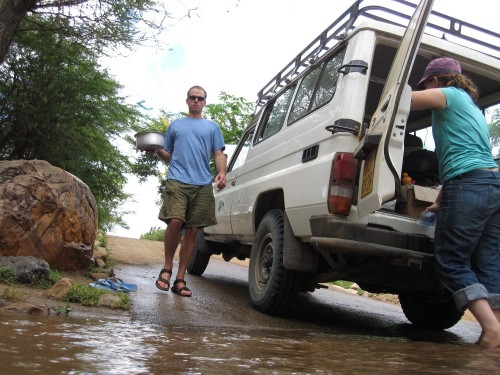
We started to see clouds coming together around noon, deciding it was prudent to make a move away from the mountain into the stony soil around the lake. This also gave us another chance for a quick dip to cool off, Erik some time to fish, and to drink a pot of chai.

This is when the rain started.

Contrary to popular belief, it does rain in the NFD, but not much. Currently it’s green and vibrant, contrasting with the normal dry, brown, dusty and arid state that you usually find it. That too isn’t abnormal. What is, is the fact that it’s been raining across the north for the last 3 days, flooding an already wet desert. People who have lived here for over 20 years have never seen it this way.

Mt Kulal

We made it to the top of Mt Kulal, to the town of Gatab that sits at 5800 feet, that evening. Kulal is God’s viewing point for all of the north. It’s a lush, green, forested environment that serves as an oasis in the desert and haven for weary travelers, such as ourselves. We could see it raining all across the horizon, from Marsabit to South Horr and even over Lake Turkana.

Besides having the chance to sleep in a non-convection oven type environment, it also provided us access to the only other hospital in the area to re-bandage my hand (Frankenstein stitches and all). We pitched the tents in a friend’s plot of land, after a great evening of chai and fish (Talapia) that we had brought up from Lake Turkana.

At 2:00am it started to rain. Not just any rain though, this was big rain, the type that feels like someone is pelting your tent with golf balls. After 10 minutes it let up. A hasty debate on the merits of pride and honor verses the fact that we had sited the tent on a strategically poor “river valley-like” side of the hill ensued. Shortly after, we made a strategic retreat for our friend’s house and piled onto the floor. That whole night I slept with a grin on my face as I heard the rain battering the mabati (sheet metal) roofing, while I remained dry and comfortable.

The next morning we found our tent 10 feet further down the hill, upside down and swamped with water. Barak and Pam’s tent was of better quality and better sited, so they emerged dry and calm the next morning. Lessons were learned.

The Run to Korr

Arapal, a town directly on the other side of Mt Kulal from Larachi was our aim for yesterday. They have had a water project going for a while, and their community has benefited greatly from it. Our goal was to hit their community, and then try to make it to Korr by the end of the day. A long day of driving, but very doable (most of the time).

By midday we again saw clouds forming, big thunderheads forming to bring the hammer of rain down on the desert. Our planned route from Arapal to Korr via Karagi we were told would be a great risk. Plan B was hatched to make a run back south of Mt Kulal and to the gap between the mountains where South Horr resides. This would be two times as long of a trip, 6 hours instead of 3.

We made a mad dash for South Horr, knowing that the rains we had seen over the area the day prior and the clouds we saw forming that day, were likely to leave us with some tough choices. By now those who know the North will realize just how much crisscrossing of the area we were doing. Our diesel was starting to run low, and there are no petrol stations anywhere. We begged some from the nun at the catholic mission in South Horr and set off for the gap.

Just after the mountains, the road splits. One branch heads directly towards Korr, the other takes you through a beautiful valley within enclosing arms of high cliffs, where you will find the town of Ngurunyet. The branch towards Korr was closed. We gamely turned towards Ngurunyet and ran until after dark to get there, only to find out that the rains had closed down the road from there to Korr completely.

It was time to camp again. We found a place by the river and held out until morning, hoping and praying that it didn’t rain. It didn’t.

Hitting Korr

At this time, you can imagine what this feels like. You’re trying like mad to get to a location, thinking through every path and camel track that you know of to get there. Obstacles keep forming, being overcome, and reforming along the way.

Everything looks better in the morning, as it did for us today.

Marsabit was closed to us, which would get us to the main road. Maralal could get us towards Nairobi, but we’re very hesitant to go that way due to the number of shootings by the ngoroko (the Turkana bandits) along that route. Korr, is where Erik used to live, where he has a house and where we can camp out for a few days, hoping that the land dries out so that we can make a run for the main road and Nairobi.

Distances are deceiving in Africa. You might be only 30-40 kilometers from another town, but that town could as well be another continent if you try to reach there during the wrong season.

Under hastily muttered prayers and hopes of a nyama choma feast in Korr, we set off. Things were going well, we had been joined 2 days previously by another vehicle full of Kenyan Food for the Hungry staff. They knew the paths, and knew how to drive. Unfortunately, like us, they were driving a large, long wheel base Landcruiser.

A Short Aside on the Merits of Landcruisers vs Land Rovers

There is a long-standing battle on which is better: Landcruisers or Land Rovers. Erik and I represent the two opposing factions, with him in the Land Rover side of the debate and myself on the Landcruiser side. Regardless of what your emotions might tell you, the Land Rover’s weak aluminum body does make it lighter so it does perform better in boggy and muddy conditions.

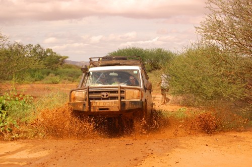
As we were the first to trek out upon this road since the rains, we had to do a lot of testing before we entered into questionable areas. Fine driving by Erik and Peter got us through most of it, until we found an area that looked like dry sand, but which had about four feet of soupy mud beneath. An hour of digging, finding rocks and lifting the vehicle later, and we were free.

I now sit in Korr, drinking some homemade lemon juice and basking in the glory that is a cool breeze after a much needed shower. We’re completely boxed into Korr now, but there is a small airfield here, even if there is no internet of mobile phone connection. For now, I’m just happy to have a dry place to sleep, a healing hand, and the knowledge of an adventure now behind me.
The Road to Turkana

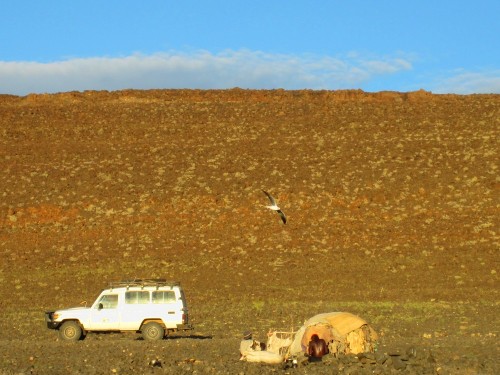
We finally made it to Loyangalani near the shores of Lake Turkana last night. A day-long drive that took us from Korr through the Ndoto Mountains and South Horr (where we had to clean out some rotten fruit in the wheel well – left overs from our time being stuck).

It’s amazing how green everything is. Even on the shores of the sunburnt and wind-blasted lake there is some grass and greenery – unusual, so I’m told. We took an hour to jump in the lake and do some fishing, but Erik only caught Tigerfish.

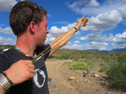
Along the way we got our first flat tire. The innertube became so hot that it separated itself. While we were changing it, Barak got out his sling. This is your stock David vs Goliath type device and it’s amazing just how far he can throw a stone with it. 200 meters is normal.

Barak grew up as a missionary kid in Papua New Guinea, besides the sling he’s got all kinds of neat gadgets and bush devices that I’d never seen before.

We capped the night off with a camp/cabin setup in Loyangalani, the night was warm and windy, and we ended up sweating most of the night in the tent. Today we head off to see a couple of water projects in the area, and I’m hopeing we make it to Gatab on the top of Mount Kulal for dinner and a cool night’s rest.

Northern Frontier District Expedition

Due to a series of mishaps and bad luck on our trek up to northern Kenya, I find myself sitting in a hoteli by the side of the road in Laisamis eating goat stew and trying to type with only one hand (my left).

Let me start at the beginning.

My childhood friend works for Food for the Hungry in Kenya, and he invited me to come on a trip with him and his funders from Blood:Water Mission into the wild west of Kenya, the NFD (Northern Frontier District). I haven’t been up to the Lake Turkana area for years, so was happy to join up, especially as it gave me a chance to test mobile connectivity and try out some GPS mapping of water projects.

I was greeted early yesterday morning by a Landcruiser with the pungent smell of goats and birds. It turned out that the vehicle had just been used to ferry goats, and that we were presently carrying 10 guinea fowl and one peacock as we were to deliver them to the Mount Kenya Safari Club on our way. A few fowl got loose along the way, and I only received one head wound in my efforts to wrestle three of them into a box while hurtling down the road at 100 Kph.

The rains have come to these usually arid lands, and all is incredibly green and lush. By about 6pm we knew we were running late as we tried to reach Korr for the evening. We took a less well-known road, that locals said they had seen a car pass through that very day. It was dark by now, and we were able to follow the tracks quite well, even through a small river and a kilometer of boggy trails.

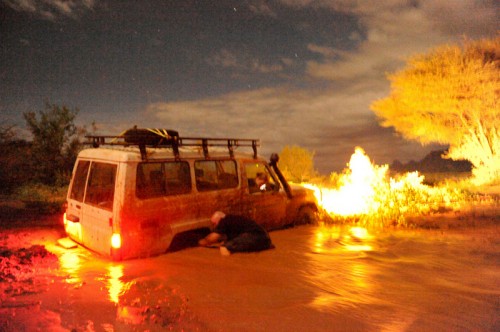
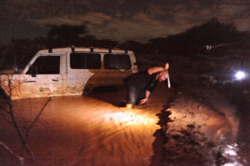
This is why when we reached a small stream, tested and waded it, that we weren’t overly concerned. Erik (my friend) gunned the engine and we dropped down into the water. What we hadn’t considered was that the already long wheelbase was made longer by a substantial bull-bar in the front and a big bumper in the rear. We promptly lodged ourselves between the two banks with only 2 wheels touching. We rushed to dig and push, but before a few minutes had passed, the river had eaten the soil out from under the tires.

For the next 3 hours we dug, pushed, rocked, cut branches and got no where, except about 2 feet deeper… At this point I would like to point out that the vehicle had shown up with 4 bad shocks and a flat tire (repaired and replaced in Nanyuki), no shovel, no winch, and a hi-lift jack that we soon found was broken. Not an optimal situation.
To keep the vehicle from becoming more submerged we built a dam near the front and dug about 5 feet of earth in the rear as a new stronger channel for the water to flow through. Our only tools were caveman-like sticks and a “simi”, a panga-like dual-sided fighting and all-purpose blade. The blade was excellent for cutting back the soil.
Unfortunately, at about 11pm, I was cutting the clay-like mud back and my hand slipped. Cold, muddy steel sliced deeply into all four fingers and the palm of my right hand. Quick action by the team cleaned and dressed the wounds, but I was stuck uselessly watching until we set up camp and fell to sleep exhausted.

The next morning Erik set off towards some hills 10 kilometers away, while we stayed with the mired down vehicle. He got through, and by 2pm our relief came walking in. He couldn’t reach us by vehicle from the front, as it appeared that the road was washed out there as well. I badly needed to get my hand stitched up and cleaned, so I slogged the 5k back with him through a road that had become a river. He dropped me off at a Catholic-run clinic in Laisamis as he went on to pull the others out from behind. The nurses sewed me up with stitches the size you’d use on a football, and the needle sticks into the wound felt great.

My goat stew is delicious, and Erik has just walked in. He tells me that they were able to jack up the rear and winch out the vehicle backwards just as another flood of water hit. The hi-lift jack and the shovel brought by the other vehicle were lost in the mad scramble for the quickly receding dry ground. Our gear is wet, scattered and dirty, but we’re all fine and on our way to Korr and, more adventure.

Pics by @justbarak

Geeking out on a Motorcycle Trip

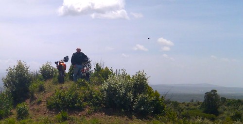
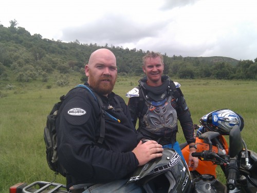
Today I had a lot of fun, one of my old schoolmates (Markus) from here in Kenya asked me if I wanted to get out of Nairobi and hit the trails on our motorcycles. Of course, the answer was yes. We headed out towards Naivasha early this morning and then took a side road off towards the escarpment.

The roads are dirt and with the recent rains they’re really quite rugged and beyond most normal vehicles. Markus is an experienced trail rider on a KTM 450 (kitted out), I’ve ridden a lot of trails, but years ago and not nearly as experienced as Markus – and I’m riding an offroad/onroad Suzuki DR 650 (stock).

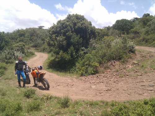
We ended up having to run through, and beside, a lot of 5-10 acre farms that sit at the base of the escarpment in order to find a road up to the top of the escarpment. A lot of this was on cow paths and required some fine-tuned leveraging of our bikes through gates and streams. The road to the top of the escarpment, when found was a fun ride, minus the part where I wiped out on a simple turn (the one below)…

Bruises (and bruised ego) aside, we kept going up into small-farm, where quite a few more people live, and which is almost entirely denuded of trees that were there just 15 years ago.

After talking to some of the local community, we were advised to head down a certain road, with assurances that it would lead us to the bottom of the escarpment. It did, eventually, but not until we had backtracked, sidetracked, followed animal trails (in buffalo country), and then realized that the washed out gully we were in was supposed to be the road.

3.5 hours of wrestling a mammoth 650cc bike through this terrain left me exhausted. This type of bike is not made for that level of technical riding down boulder strewn gully’s and game trails. However, it was also hugely rewarding when we finally found our way to the bottom of the escarpment and much easier riding.

Mapping the Malewa Motorcycle Trip

I also brought my Android Nexus One along for the ride, hoping that the battery life would allow me to use it for tracking our trip. The Nexus One has a GPS, and there’s an Android app called My Tracks, that tracks your trip, allows you to add waypoints, then easily shares it to Google’s MyMaps.

Here is the result:


View Malewa Motorcycle Trip in a larger map

It doesn’t look very exciting like that, but it does give you the exact data for having your own challenging ride if you’re in Kenya.

Obama’s New Media Strategies for Ghana

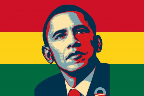
A couple weeks ago I had a discussion with President Obama’s New Media team, where we talked about what they might do to reach out to ordinary Ghanaians on his trip next week – which will culminate in his speech in Accra on July 11th. There is a lot of excitement in Africa around Obama, and this trip is going to set the continent humming.

Obama in Ghana - 2009

WhiteHouse.gov/Ghana isn’t live yet, but on July 11th, it will become available. They are going to stream the talk at whitehouse.gov/live.

It’s a fairly interesting initiative to undertake, with a slew of problems, as you try to engage with as many individuals in an open travel campaign as possible. At the same time, you know that any channel you open up will get absolutely flooded with incoming comments, questions and spam of every sort. In the end, the team decided that Radio, SMS, then Facebook would be the primary new media access points – and in that order.

Radio, SMS and Facebook

Radio is still the number one communications medium across Africa, and Ghana has a particularly vibrant and active one with a lot of local and national community interaction.

As everyone knows, mobile phone penetration has grown at an explosive rate in Africa, this means that SMS is a fairly democratic means for getting feedback from people of every demographic across the nation. (Funnily enough, not available to US-based residents – more below on that)

Lastly, there are no major homegrown web-based social networks in Ghana, and like many other countries across Africa Facebook has a decent amount of penetration. In Ghana, it’s at 100,000+, so it makes the most sense for the new media team to engage and interact without splitting their energy over too many services. Having Twitter on as a backup is natural, as there will be a great deal of chatter there as well.

The details (from the White House)

SMS. We’re launching an SMS platform to allow citizens to submit questions, comments and words of welcome (in English and in French) . Using a local SMS short code in Ghana (1731) , Nigeria (32969) , South Africa (31958) and Kenya (5683), as well as a long code across the rest of the world*, Africans and citizens worldwide will be encouraged to text their messages to the President. SMS participants will also be able to subscribe to speech highlights in English and French. Long numbers for mobile registration pan-Africa: 61418601934 and 45609910343.

This SMS platform is not available to US participants due to the Smith Mundt Act (The act also prohibits domestic distribution of information intended for foreign audiences).

Radio. A live audio stream of the President’s speech will be pushed to national and local radio stations during the speech. After the speech, a taped audio recording of the President’s answers to the SMS messages received will be made available to radio stations and websites. The President hopes to answer a variety of questions and comments by topic and region. The audio recording will also be made available for download on White House website and iTunes.

Video. The speech will be livestreamed at www.whitehouse.gov/live. The embed code for this video is available so you may also host the livestream on any Website.

Online chat. We will host a live web chat around the speech on Facebook (it will be at http://apps.facebook.com/whitehouselive). The White House will also create a Facebook “event” around the speech wherein participants from around the world can engage with one another. A Twitter hashtag (i.e. #obamaghana) will also be created and promoted to consolidate input and reaction around the event.

Obama talks about his upcoming trip

Part 1

Part 2

© 2024 WhiteAfrican

Theme by Anders NorenUp ↑

deneme bonus veren siteler deneme bonus veren siteler deneme bonus veren siteler