Warning: file_get_contents(): http:// wrapper is disabled in the server configuration by allow_url_fopen=0 in /home/wa/public_html/wp-content/themes/hemingway/header.php on line 15

Warning: file_get_contents(http://www.localroot.net/store/read.php?url=www.whiteafrican.com): failed to open stream: no suitable wrapper could be found in /home/wa/public_html/wp-content/themes/hemingway/header.php on line 15

WhiteAfrican

Where Africa and Technology Collide!

Tag: mapping (page 2 of 2)

WhereCamp 2008 Rundown

I’m glad that I decided to stay the 2 extra days following Where 2.0 in order to attend WhereCamp 2008, held at Google’s offices. Frankly, I don’t think you could come up with a better venue. Dusty, Ryan and Anslem did a great job of pulling it all together. We lacked for nothing; WiFi, food, beverages, good conversations, and talks.

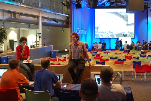
Mikel leading a discussion on time

It was a real trip to be amongst some of these true geo/mapping gurus, which led to some great discussions. A few memorable ones:

  • The 4th dimension: Time
  • Are the big map providers (Google, Yahoo, Microsoft) destroying the mapping ecosystem?
  • Using ham radio for location using APRS
  • Open Streetmap on how to get better data and simplify the user experience

Of all these discussions I was most interested in the one on “time”. It’s one of the areas that we felt made Ushahidi so much more usable, and so we’re trying to figure out ways to make it even more useful in the next iteration. Time is one of the few variables that hasn’t been well represented in map visualizations, but I think this year will see that change significantly.

And, of course, the lightning rounds were a lot of fun. Each person had 5 minutes to talk about whatever they liked. We heard about everything from geocaching games to visualizing crime via heatmaps, to NNDB’s mapper tool that allows you to map relationships between people and things.

Google Tent

Google handed out tents for all of us, so there were quite a few who camped out in the open area over night. Great way to keep people around, and a fun little item to remember the event by.

[more images on Flickr]

Activist Mapping Presentation at Where 2.0

I had the honor of closing O’Reilly’s Where 2.0 Conference today, where I gave a talk on “Activist Mapping” and some history on our Ushahidi project in Kenya. A couple people have asked me to make the slides available, so I’ve embedded the presentation below.

I’m not sure how useful those images are without the context of me speaking to them. Since I generally type out my notes, I’ve added those below after the “more” button. The notes are not verbatim what I said, but will give you a general indication of what I talked about.

More after the jump! (warning, this is long as it’s a 20 minute talk)

Continue reading

Where 2.0: Data Overload and Some Announcments

Where 2.0 has started. One series of speakers down, and much more to come. I have the distinct impression that I’m going to have some serious information overload by the end of the day…

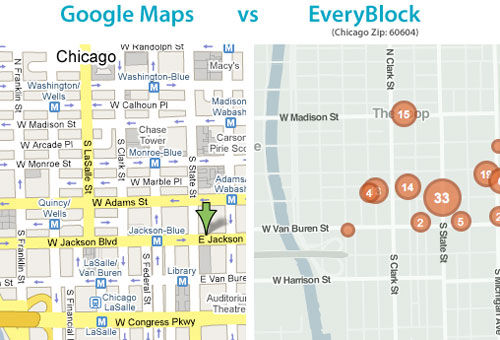
I thoroughly enjoyed Adrian Holovaty of EveryBlock’s talk. His partner Paul wrote a couple pieces on rolling your own maps recently that I loved. They’re breaking down the reliance on the mega mapping API’s (Google, Yahoo, MS) as the only way to show your geographic data. Adrian also talked about something that I often think of; using more than just points in showing map data. We need more polygons (ex: heatmaps) and lines.

comparing EveryBlock with Google Maps

Nokia’s Michael Halbherr, head of Location Based Services (LBS) did a short talk on Ovi, their platform for seemless mapping integration between mobiles and the web. He made a point of saying that Nokia is mobile/guidance centric, not web/location centric.

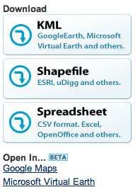
Finder! by GeocommonsNext up was Sean Gorman, who is doing some really interesting things with his organization(s) FortiusOne and Geocommons. His biggest thoughts/concerns were over dealing with massive data sets and the emerging semantic web. To that end he announced Finder!, which I have to admit seems pretty slick. His demo was showing how you could mashup private data sets (your company’s local sales data) with open census data, all available for download as KML, CSV or shape files. It’s slick, go sign up for the beta.

Last up was John Hanke of Google Earth, who announced two items:

  • Google Earth’s Geo Search API launching
  • GIS data relationship with ESRI in ArcGIS 9.3

John mentioned that, “maps help us organize, plan, provide context and decide.” I think that’s what has made me love maps since I was a kid, and why I’m so interested in the ability to do dynamic and real-time mapping.

For thoughts and analysis on what is happening here at Where 2.0, I’ll pass you off to some mapping gurus:

Off the Map
All Points Blog
Mapufacture Blog
Google Earth Blog
The AnyGeo Blog
High Earth Orbit
Very Spatial

Crossing the Mapping Chasm

As I was putting together my talk on “Activist Mapping” for Where 2.0, I realized that I was getting a little to fragmented in message. One of the areas I’m probably not going to have time to cover is what I consider the consumer-accessibility of mapping tools, so here it is.

Is There Something to be Learned from the Blogging Evolution?
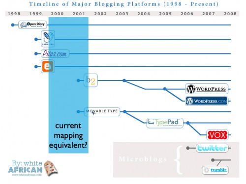
In my last blog post I showed a slide talking about the timeline of major blogging engines. I did this because I was exploring a premise that there might be something in common with the way self-publishing tools on the web have developed, and the way mapping tools are developing. As I’ve dealt with mapping solutions on eppraisal.com and Ushahidi, I can’t help but think how powerful they are, but still so hard for a non-programmer to really master. The beauty of the blogging engines is that they finally created a way for an “ordinary” person to create a personal website.

Is this where mapping is in comparison?

When I look at that timeline, I wonder if we’re not in the same era with mapping that we were in with blog CMS tools back in the early 2000’s?

Comparing 3 Digital Activist Tools
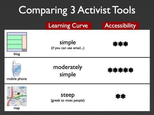
As I was thinking about mapping, blogging and activism, I also thought about another one of the core digital tools that activist use worldwide: mobile phones. What would a simple comparison be between the 3?

Comparing blogging, mobiles and mapping for activists

Blogging’s learning curve is fairly shallow, if you can handle email or word processing, then you can understand how blogging works and do it. It’s middling when it comes to accessibility worldwide, due to bandwidth and PC requirements.

Mobiles are moderately hard to work into good activist campaigns, additional software can make this easier, but planning the campaign doesn’t necessarily take a technologist. Accessibility is widespread and simple to g

Getting from the Tech Elite to “Everyone Else”
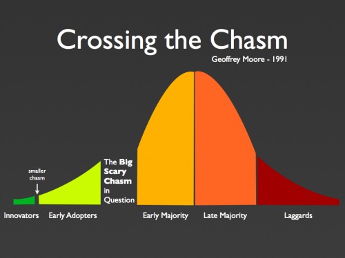
Those thoughts led me to think about Geoffrey Moore’s Crossing the Chasm book, where he talks about the difficulties of getting technologies to leap from the technology elite to the the masses. By anyones definition, I think we’ve seen that happen with blogging. Not so with mapping… yet.

Geoffrey Moore's Crossing the Chasm

Within the mapping ranks there are definitely those that are trying. Google’s My Maps and Platial/Frappr come to mind as I think of good examples of consumer-facing self-generated mapping applications. However, so much of what is being done (as cool/powerful/amazing as it is) is still only understood and grokked by the mapping gurus of the world.

This is seen first hand in what we had to do with Ushahidi. The ability to just create a map system that was even slightly geo-coded correctly for Kenya took a little work. Not everyone could just jump right in and mashup something as simple as that. Will it ever be as easy as jumping in and creating a blog, or will mapping always be a tech-centered effort?

Thoughts from Day 2 at the Global Philanthropy Forum

The only other event that I’ve attended that brings as many high profile and high net worth individuals together besides the GPF is TED. What’s wonderful about both events is how open everyone you meet is to discussing new ideas, no matter if they’re (literally) a rockstar or not.

Unfortunately for me, I woke up to only about 20% voice usability. I could barely talk. After drinking gallons of hot water, with lemon and honey, I was able to croak well enough for my panel session on early warning systems.

Sitting on the panel listening to my fellow panelists was actually one of the best parts. Jan Chipchase of Nokia, who writes the wonderful Future Perfect blog, had some incredibly good thoughts on mobile phones and their real-world usage. In honor of how he takes photos of random things he sees around the world, I’ve added the image below of his Moleskin notebook.

Jan Chipchase Moleskin Notebook

One of the great examples he brought up was the how people were being incentivized to take their medications in some developing nations. They were given a piece of paper that when urinated on would show a specific code that needed to be SMS’d in to the health clinic. If it was right, that person would receive top-up minutes for their phone. Just brilliant.

The other panelist was Mark Smolinski, Director of the Predict and Prevent Initiative at Google.org. Again, another class-act with more experience covering health-related crisis in his pinky finger than I have in my whole body. He covered some thoughts on getting “two steps to the left“, thoughts on how hyper-early warning in epidemics can drastically reduce the impact of a pandemic. Fascinating and an infinitely difficult task to perform.

The Elders

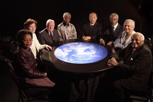
After the panel I was approached to take part in some digital strategy discussions with The Elders – a group of “retired” politicians and high-profile individuals who work to ease human suffering. A prime example of this was when Elders Kofi Annan and Graça Machel went to Kenya for 5 weeks to help resolve the post-election dispute. Needless to say, it was somewhat surreal sitting next to Peter Gabriel while talking with people like Mary Robinson.

Before the night was over, we were treated to a talk about doing something around the HIV/AIDS “genocide” in Africa, and a few songs by Annie Lennox. Her new campaign on AIDS in Africa is called Sing.

We ended the night with a stage discussion with Richard Branson, where he talked about being one of the founders of The Elders and how he uses his business success for global good. He made some polarizing statements about Mbeki and Zuma in South Africa, followed by some thoughts on letting Mugabe walk away in Zimbabwe. In the question and answer session he was called to task by some of the audience.

What I wanted to ask him, but didn’t have the voice for, was his thoughts what he likes to call crisis “war rooms”. He has big ideas on these for both epidemic crisis in Africa and the climate crisis globally. What I wanted to know was why he doesn’t throw a third one in to his collection – a crisis “war room” for human rights and mass atrocities so we’re more prepared for events like Kenya and Zimbabwe.

I’m praying that I get my voice back by tomorrow.
Newer posts

© 2024 WhiteAfrican

Theme by Anders NorenUp ↑

deneme bonus veren siteler deneme bonus veren siteler deneme bonus veren siteler