iHub Research continues to put out great research for clients. They also take time to put together the numbers for everyone else as far as what’s going on in our part of Africa.
Mobile & Internet Stats for East Africa
The most recent stats for East Africa’s mobile and internet usage have been put into an new infographic.
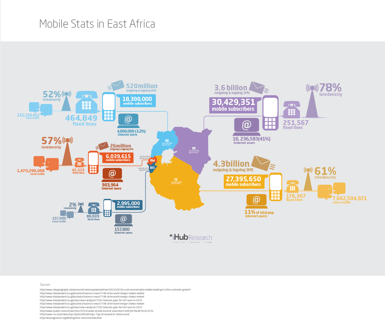
Mobile and Internet use in East Africa, an infographic by iHub Research
Here is a dump of the data used for this infographic:
Kenya Mobile Statistics
(Population: 44,037,656 July 2013 estimate)
30,429,351 mobile subscribers
16,236,583 (41%) Internet users
3.6 billion outgoing & incoming SMS
251,567 fixed lines
78% teledensity
Tanzania Mobile Statistics
(Population: 48,261,942 July 2013 estimate)
27,395,650 mobile subscribers
5,308,814(11%) Internet users
4.3 billion outgoing & incoming SMS
176,367 fixed lines
61% teledensity
7,662,504,921 voice traffic
Uganda Mobile Statistics
(Population: 34,758,809 July 2013 estimate)
18,300,000 mobile subscribers
4,800,000 (3.2%) Internet users
520 million outgoing & incoming SMS
464,849 fixed lines
52% teledensity
215,110,452 voice traffic
Rwanda Mobile Statistics
(Population: 12,012,589 July 2013 estimate)
6,039,615 mobile subscribers
903,964 Internet users
26 million outgoing & incoming SMS
42,323 fixed lines
57% teledensity
1,470,290,068 voice traffic
Burundi Mobile Statistics
(Population: 10,888,321 July 2013 estimate)
2,995,000 mobile subscribers
157,800 Internet users
80,039 fixed lines
2% teledensity
157,800 voice traffic
Sources:
http://www.telegeography.com/products/commsupdate/articles/2013/03/19/u-com-burundi-adds-mobile-banking-to-drive-customer-growth/
http://www.independent.co.ug/business/business-news/7748-airtel-warid-merger-shakes-market
http://www.independent.co.ug/news/news-analysis/7332-telecoms-gear-for-turf-wars-in-2013
http://www.independent.co.ug/business/business-news/7748-airtel-warid-merger-shakes-market
http://www.reuters.com/article/2011/07/22/ozabs-econet-burundi-subscribers-idAFJOE76L0EY20110722
http://www.cio.co.ke/news/top-stories/Africell-buys-Tigo-to-expand-in-Sierra-Leone
http://dlca.logcluster.org/BDI/logistics-services/index.html
CIA World Factbook
2011/2012 Stats and Infographic
Here’s the 2011/2012 numbers for all of the countries in East Africa, plus some bonus numbers around mobile money at that time.
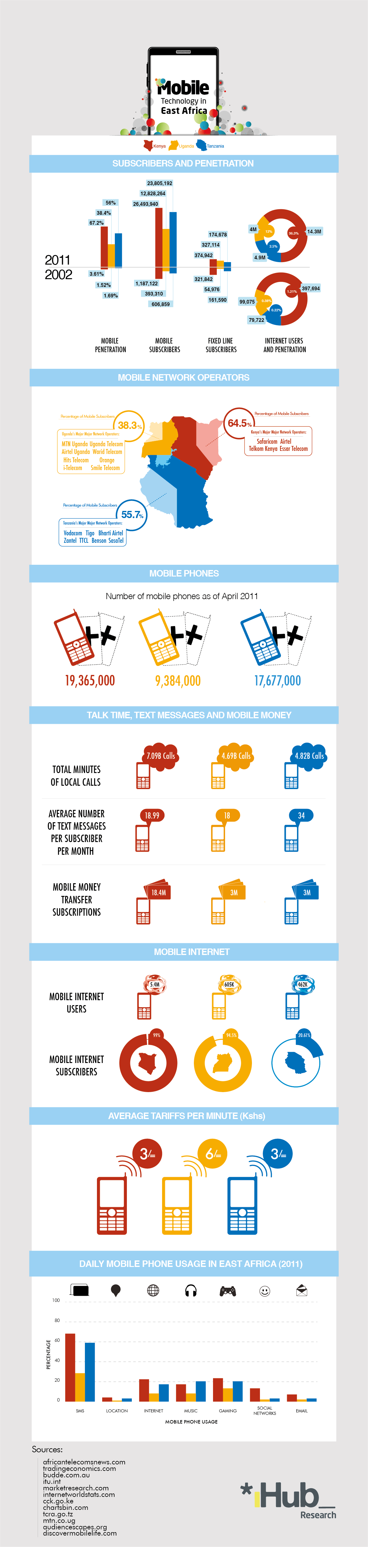
2011 and 2012 East Africa mobile and internet statistics infographic by iHub Research
See the old ones from 2011 in Uganda, Kenya and Tanzania. You can also see the some 2012 numbers on the iHub that they put together as well.


