Private Equity Investment in Africa 2013
Private Equity info Map of Africa – 2013 (PDF Download)
There was a total of 83 PE deals. 44 were reported totaling $4.3 billion.
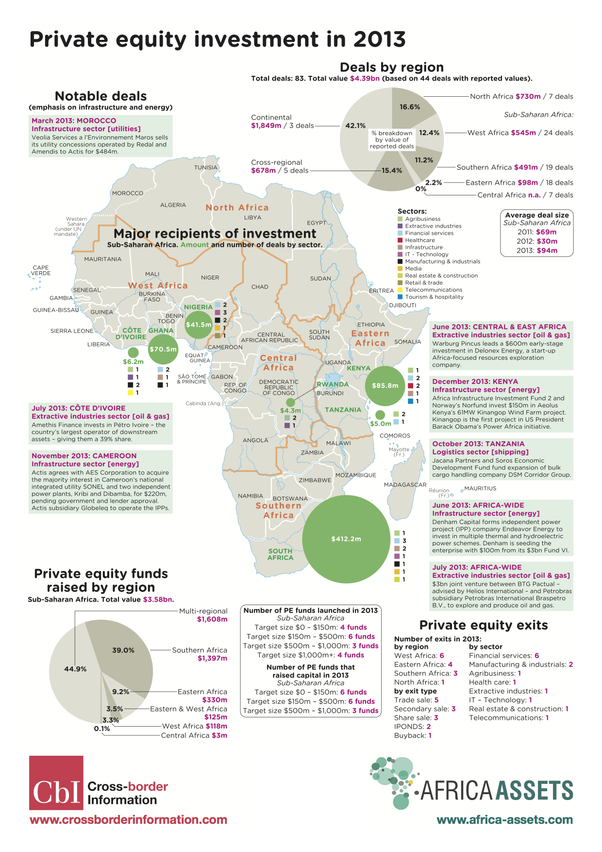
Private Equity info Map of Africa – 2013
Infrastructure Investment in Africa 2013
Africa Map of Infrastructure Investments in 2013 (PDF Download)
If you add up all of what Europe, the US and all the multilaterals together put into Africa, the total is $15,368,000,000 ($15.4b USD). China alone put in $13,360,000,000 ($13.4b USD). Is it any wonder that the African leaders of today look east to China more than the west to the US and EU?
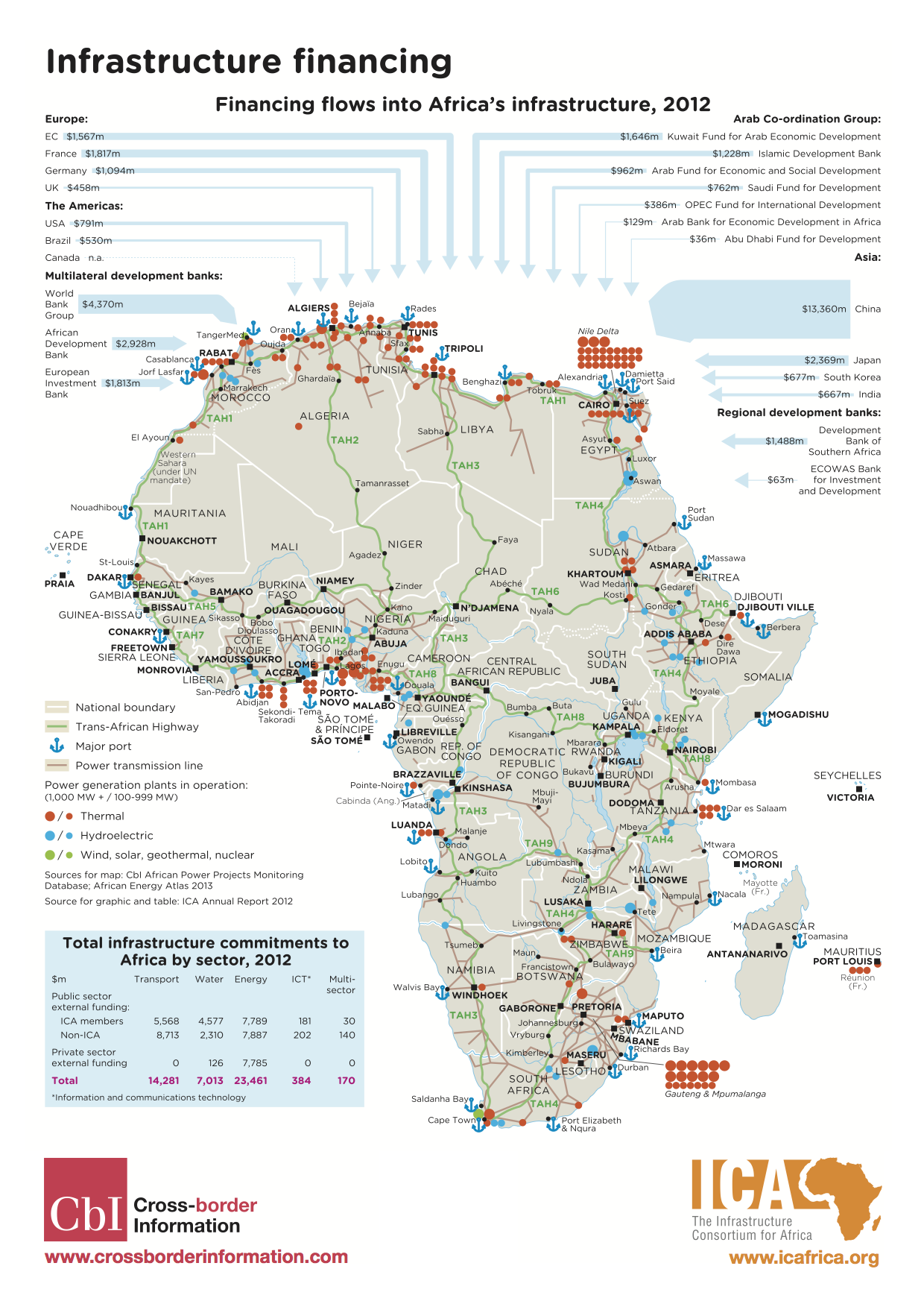
Africa Map of Infrastructure Investments in 2013
Tech Hubs in Africa – 2014 Map
[Tech Hubs in Africa 2014 – PDF Download]
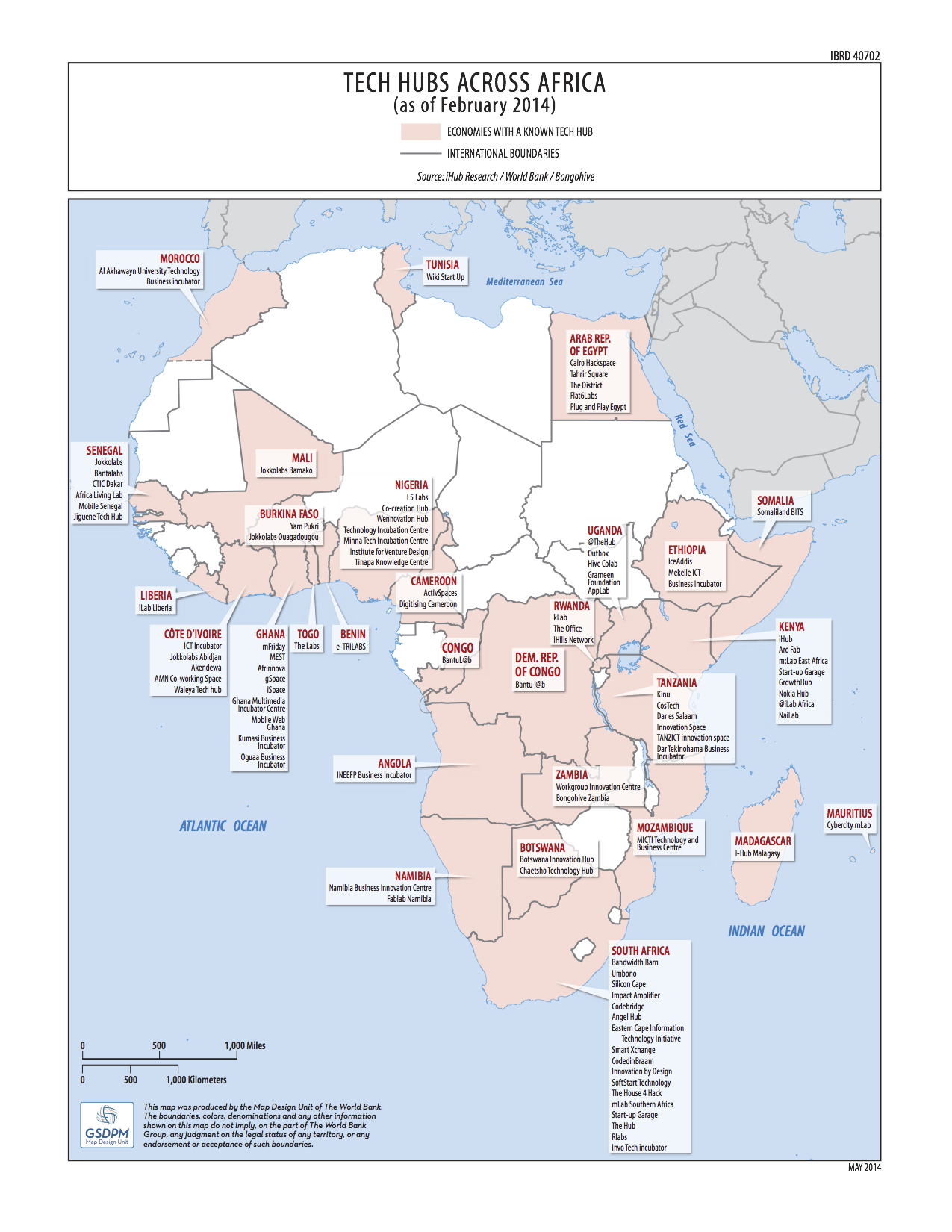
There are now 90 tech hubs/labs in 28 countries around Africa.
A current 2014 map of tech hubs in Africa, done by the World Bank, iHub Research and BongoHive. Read the original article here, “Tech hubs across Africa: Which will be the legacy-makers?” by Tim Kelley.
As exhaustive as this is, I think there are a few missing. I believe that there are two new ones in Zimbabwe not showing up, Muzinda Hub and Hypercube Hub (though, I’m not 100% that they’re up and going as running spaces). All that to say, more keep cropping up, and that’s a good thing.
+ JoziHub, which is also missing.
]]>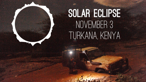
BRCK Solar Eclipse trip, photo courtesy of Barak Bruerd on our last trip up to Northern Kenya
This week finds me heading back, chasing the moon that will cover the sun. November 3rd at 5:30pm (East Africa Time) there is a hybrid solar eclipse. The lunar-like desert setting on the edge of Lake Turkana is said to be the best place in the world to watch it.
This also happens to be one of the most difficult places to get to, as fuel and supplies are a difficult thing to come by for the final 1000 kilometer loop. You have to bring it with you. It’s an unforgiving place, and yet one of the most hauntingly untouched and beautiful stretches of Africa that you can still find.
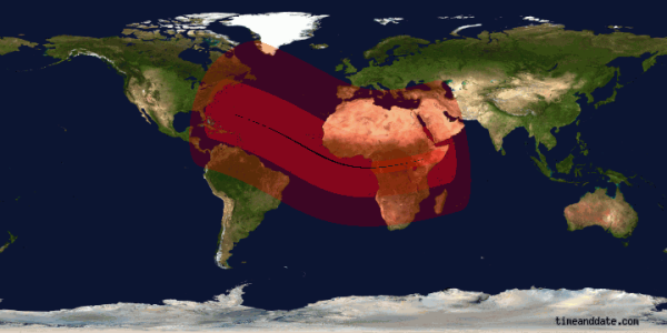
Solar Eclipse Path, Nov 3, 2013
Though one never needs an excuse to have an adventure, the BRCK team is using this trip to stress test the device. We have a number of things planned, covering ruggedness and heat to testing out an amplification antenna with it. With luck, we’ll even have a VSat connection in hand, and test out WiFi via satellite internet backhaul and stream the eclipse live. You’ll be able to watch that at BRCK.com/eclipse.
[update: Huge thanks to Indigo Telecom for loaning us a BGAN terminal and 50Mb of data!]
Seven of us are trekking up to this iron triangle; where Sudan, Ethiopia and Kenya meet. We’re taking three 650cc motorcycles and a Land Rover 110. Two happen to be professional photographers, two others are highly talented amateur photographers, and I’m going as the hack iPhonographer. 
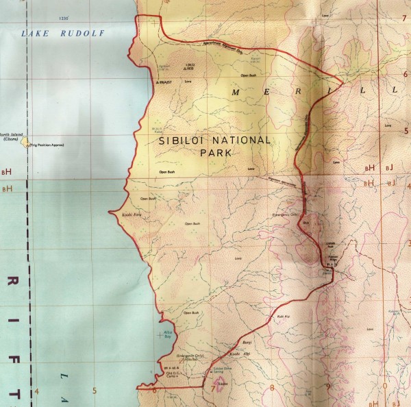
Sibiloi National Park, by Lake Turkana in Northern Kenya
Our destination is Sibiloi National Park (KWS site), possibly the least visited and most unknown park in Kenya. It’s a good few hours drive north of Loyangalani, which I’m curious to see after the past few years. As far as I can tell, there is really no reason to ever go there, well, except for an eclipse…
I’ll be blogging our adventures here, as well as with others on the BRCK Blog. You can follow the images and livestream at brck.com/eclipse.
[Note: It should go without saying, but I won’t be answering many emails…]
]]>
UPDATE: Here’s the report put together by the iHub Research team (3Mb PDF): Uchaguzi Kenya 2013
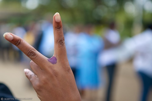
The elections in Kenya this year have had a lot of drama, nothing new there. As I wrote about last week, Ushahidi has been involved quite heavily on the crowdsourcing side via Uchaguzi, which meant that we had an exhausting week as the results kept getting extended each day.
Uchaguzi Update
Some basic statistics:
- 5,011 SMS messages sent in (that weren’t spam or junk, as those got deleted)
- 4,958 reports were created (from SMS messages, the web form, email and media monitoring teams)
- 4,000 reports were approved to go live on the map
- 2,693 reports were verified (67% of approved reports)
Notes and Links:
- Many reports, links an updates can be found on our virtual situation room
- The analysis team provided twice daily rundowns based on verified data at http://visuals.uchaguzi.co.ke/
- Rob created a map visual to show the reports coming into Uchaguzi over time.
- The IEBC tech system failed, I started a Tumblr trying to figure out how the system was built, which companies were involved and what they did, and what actually went wrong.
- Before the IEBC tech system was shut off, Mikel used their API to create maps (1, 2) and Jeff and Charles created a mobile-friendly results site as well.
- Heather wrote up a good post on our situation room blog about what we’ve learned along the way.
Here’s an Uchaguzi community graphic:

Just over 5 years ago, I was just like everyone else tuning into the social media flow of blogs, tweets and FB updates along with reading the mainstream media news about the Kenyan elections. We all know the story – thing fell apart, a small team came together and built Ushahidi, and we started building a new way to handle real-time crisis information. We were reacting and behind from the beginning.
(side note: here are some of my early blog posts from 2008: launching Ushahidi, the day after, and feature thoughts)
Now, the day before Kenya’s elections, I’m sitting in the Uchaguzi Situation Room, we’ve got a live site up already receiving information, 5 years of experience building the software and learning about real-time crowdmapping. There are over 200 volunteers already trained up and ready to help manage the flow of information from the public. This time Kenya’s IEBC is ready, they’re digital, and are doing a phenomenal job of providing base layer data, plus real-time tomorrow (we hope).
In short, we’re a lot more prepared than 2008 in 2013, everyone is. However, you’re never actually ready for a big deployment, by it’s very nature the crowdsourcing of information leads to a response reaction, you’re always behind the action. So, our main goal is to make that response processing of signal from noise and getting it to the responding organizations, as fast as possible.
Uchaguzi 2013
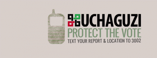
If you’d like to know more about the Uchaguzi project, find it on the about page. In short, Uchaguzi is an Ushahidi deployment to monitor the Kenyan general election on March 4th 2013. Our aim is to help Kenya have a free, fair, peaceful, and credible general election. Uchaguziâ€ s strategy for this is to contribute to stability in Kenya by increasing transparency and accountability through active citizen participation in the electoral cycles.This strategy is implemented through building a broad network of civil society around Uchaguzi as the national citizen centred electoral observation platform that responds to citizen observations.
The next couple days I’ll be heads-down on Uchaguzi, running our Situation Room online and Twitter account (@Uchaguzi), and troubleshooting things here with the team. We’re already getting a lot of information, trying to work out the kinks in how we process the 1,500+ SMS messages that people have sent into our 3002 shortcode, so that tomorrow when things really get crazy we’re ready.
I’ve already written up a bunch on how Uchaguzi works, so I’ll just post the information flow process for it here:

Uchaguzi’s workflow process
Your Job
As in 2008, your job remains the same; to get the word out to your friends in Kenya, to get more reports into the system, and to support groups working towards a good election experience.
A huge thank you to the local and global volunteers who’ve put in many, many hours in the workup to tomorrow and who will be incredibly busy for the next 48 hours. Besides the hard work of going through SMS messages and creating geolocated reports out of them, some of the geomapping team have been busy taking the police contact information and mapping it. They’ve created an overlay of the data, it’s on this page right now, but our plans are to put this on the main map later.
Just as in 2008, a few people are making a big difference. All of the volunteers doing the little they can to make their country better.
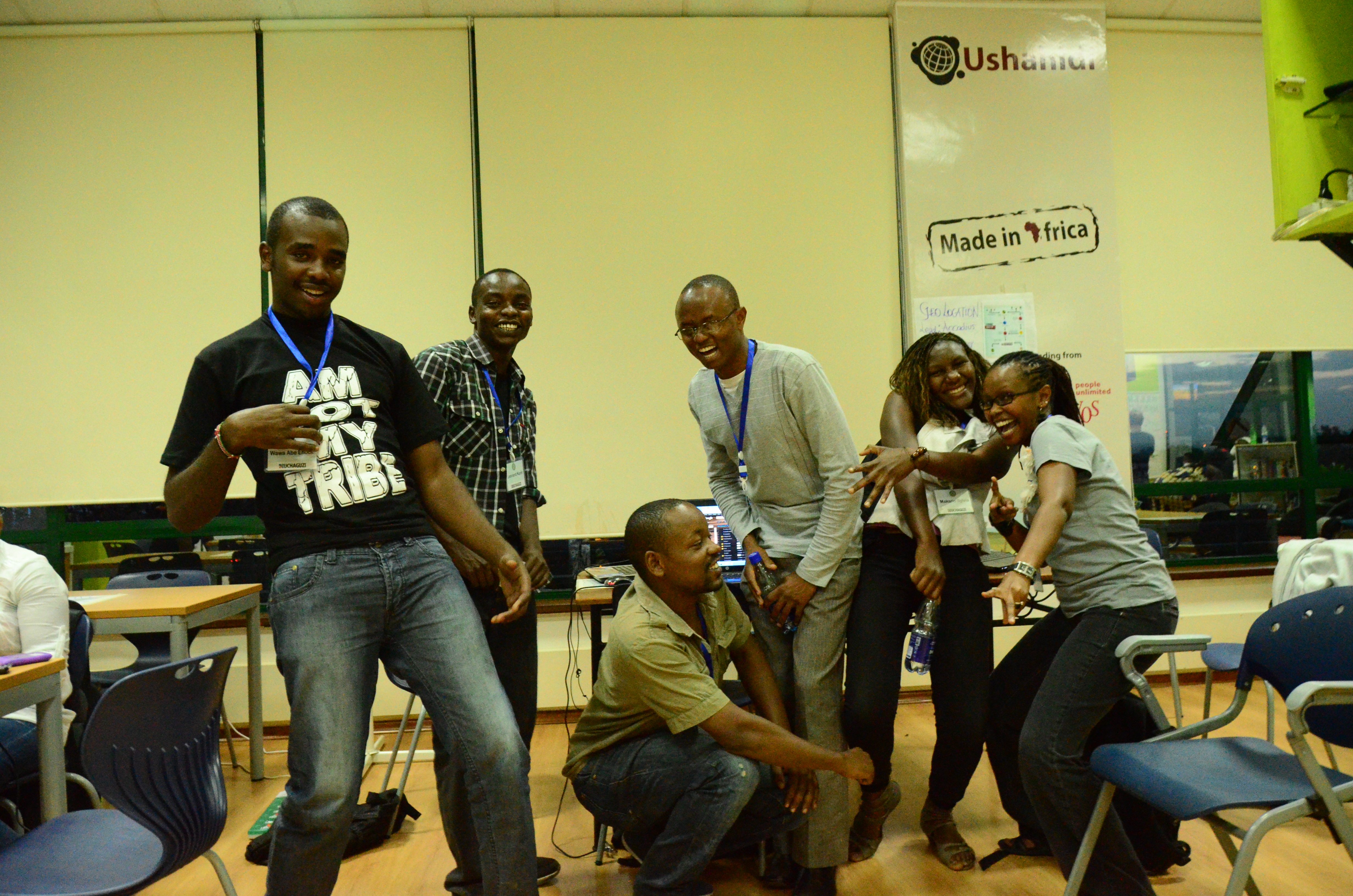
- Leonard Korir
- Samuel Daniel
- Luke Men Orio
- Slyvia Makario
- Wawa Enock
- Mathew Mbiyu
Some other helpful links for the Kenyan elections
IEBC
Find your polling station
Voter education
Mzalendo
Got To Vote
Wenyenche
Google Elections Site
The Kenyan Human Rights Commission
Mars Group
Kenya Nation Election Coverage
Standard Media Kenya
Kenya’s Freedom Media Council

“In the game, the Echo is a parallel virtual universe based on the South African map. Instead of cities and skyscrapers, however, players will find rolling green fields, rocky outcrops and valleys to explore and establish their base.”
The best overviews are found on the News24 Games blog, in an interview with co-creator Nic Haralambous, and on Nic’s own blog (you’ll also want to read what Vincent Maher had to say about it). From what I can tell, without having played it yet, is that it’s a turn-based card-type game. You find loot, do battle and win more loot. Leveling is there, but it’s not as large of a component as expected.
“There are lots of different kinds of weapons, powers and items that you can pick up by moving around the country from city to city, province to province. Each one gives you a slightly different edge in battle.”
On top of the normal game elements, and an indicator that makes me believe that LoE might be better thought-out than most other games, is the fact that they built an economic system into the game from the beginning. Nic states, “There is a currency model built in to the game that allows players to spend airtime in the Echo Marketplace.” That’s a big deal, and it’s not easy to pull off if done right.
Legend of Echo’s graphics and visual appeal can’t be understated. They spent a good deal of time to make this game look and feel like a World of Warcraft competitor, and it shows. Visually it reminds me of Arcanum meets World of Warcraft.

Specs
You’ll need to have a high-end Nokia or Sony Ericsson to play Legends of Echo. I’ve got an old Nokia N95 sitting around somewhere, so my plan is to dust that off and give the game a run when I’m in Cape Town next month.
It also appears that you actually have to be in South Africa to play it, but I’m checking with Nic to see if anyone living in a country that The Grid operates in can play it as well. This is doubtful, as it’s based also on the Afrigis system, which is fairly Southern-Africa specific.
The game is available for free as a Java download to cellphones. To play Legends of Echo, SMS ‘ECHO†to 33313 (50c/SMS) or visit http://www.legendsofecho.mobi
A teaser video:
Legends of Echo from Cow Africa on Vimeo.
Thoughts from a gamer…
- It seems that a web-based Java version of this game would be successful, if only because it would allow you to play on whichever device you have handy. Are there any plans for that?
- How much will LoE go the direction of Foursquare where they really use the location based systems to drive competition and increased game play?
- I’m impressed that they took the time to create a strong virtual economy.
- Will a real-world economy of people using real money to buy and sell goods develop online, as we’ve seen in other successful MMO games?
- You’re supposedly able to “Build special items with unique abilities”. I’d like to know more about the crafting system, as that can be one of the best ways to deepen interaction and make a game more unique.
Google continues getting Africa on the map
Google Maps was launched in 30 Sub-Saharan African countries. That’s an amazing asset for everyone to use, and it’s also an incredible testament to the number of users using their “My Maps” feature, as this is where this data comes from.

On the growth of tech hubs in Africa
Rebecca Wanjiku wrote an article on IDG about, “Tech labs move beyond corporations in sub-Saharan Africa“. She’s a member of the Nairobi iHub advisory group, and has more insight than most in this space.
South Africa’s Design Indaba
It’s happening right now in Cape Town (Feb 24 – 26, 2010). Great design, and great speakers, but I was really intrigued by their kids program.

Location based service launches in Nigeria
StarTrack is a new location based tracking service in Nigeria, Loy Okezie has a good overview of this new service from Starcomms.

University Students and the Aid Industry
Last night I spoke to a group of university students for 3 hours at the University of San Francisco to Wanjiru Kamau-Rutenberg’s class on “the Politics of International Aid and Development”. My bent is towards technology and the practical applications of such in Africa. I’m no expert on international aid, but that didn’t stop us from having a lively debate on what works and doesn’t work in Africa.
My main points were centered around technology allowing people to bypass government (and other) inefficiencies in Africa – creating opportunity where none existed before. In my experience, most aid programs don’t work, in fact we’ve seen more good come out of the mobile phone industry’s foray into Africa over the last 10 years than we’ve seen in the past 50 years of aid work.
Some questions that arose during the conversation, each of which we could have spent a day unpacking and dissecting in detail:
- Can wealth generation alleviate the ills of Africa?
- Is corruption trickle up or trickle down?
- Should corruption just be seen as a “cost of doing business”?
- What’s the most compelling innovation that you’ve seen come out of Africa?
- Is there such a thing as “good aid”?
This morning I spent some time with the Google.org and the Google crisis mapping team discussing ideas and thoughts about what we all did in the digital space around Haiti. More importantly we asked the question, “what are we going to do the next time a huge global disaster strikes?”
That’s an important question because we need to ensure that we’re further along next time. That, the next time disaster strikes we’re ready with a toolkit of useful applications and platforms that can all be deployed within just a few short hours.
One of the cool things to see was the Google street mapping vehicles parked in a row.

Citizen Space
 There are more and more co-working spaces showing up all over the world, including our own iHub in Nairobi. However, one of the early pioneers in this was Citizen Space started by Chris Messina and Tara Hunt. My main purpose visiting was to see how it’s setup and how it has changed since I last visited a couple years ago.
My takeaways: big open space, desks and cool eclectic design. Rent desk space and have a cool vibe about it. I’m sure there’s more than this, but it’s what struck me during my short visit.
Most of the afternoon was spent at Twitter where I gave a lunchtime presentation. Ryan Sarver, head of platforms and the API, asked me to do more general talk on innovation in Africa starting with AfriGadget. Having a good 50-60 Twitter employees listening in on AfriGadget, then a talk on mobile phones in Africa, and finishing with the Ushahidi usage in Haiti was interesting to say the least.

The questions asked made me realize that there’s a good opportunity for top-end Twitter employees (and likely other high-level techies from Silicon Valley) to stretch themselves a little bit, head out to Africa and really see what’s going on. They would probably get some ideas that caused them to be a little more creative back in the US.
A longer discussion was had with the leads for the Geo/Mapping team and the Internationalization team. More refreshing than anything else was realizing how open they were to outside ideas and how willing they were to listen. Twitter is doing a lot of things to make sure that their platform is more accessible all over the world, and I think we’ll see some pleasant surprises this year in Africa.
Summary
There’s obviously much more to discuss than this brief summary can do justice to, but not all of it can be put down at one time, or is even relevant at this stage in the game. What I’m excited about is the fact that more people in the Bay Area are talking about relevant issues to African technologists and that there are opportunities for the two groups to start interacting in ways that haven’t been that common in the past. There’s room for both sides to learn from the other.
]]>A number of us in the Nairobi tech community have been discussing the need for a physical nexus for the tech community here for a couple years, so it’s great to finally be so close to uncorking the bottles and celebrating a big step forward for all of us.
iHub opens on March 3, 2010!
Here’s a rough video of the iHub. A first-look at the space, before any design or wiring is done:
[Note: my apologies for the video quality, it was taken with my phone.]
Background and Info
The iHub will have a redundant 10Mbs connection, hardwired and WiFi, and it’s freely available to any tech person in Nairobi to use once they become members. Membership is free, our only requirement is that you are indeed involved in the tech space as a programmer, web designer or mobile application developer.
Data connectivity is the most important aspect of the iHub, but after that comes a fresh design and an atmosphere that is conducive to techies getting cool stuff done.
Finally, we’re putting our networks into place to give special access to the entrepreneurs and startups who need space to meet with VCs, seed funders and local businesses. We’re trying to create the place where seeds are planted and are easily found by the people with money to help them grow.
A Blank Canvas
The iHub is what we as a tech community make it. It is a blank canvas, a big open room with a great view and wonderful location, but still an empty room that needs some input from people within the community to design, and create a culture around.
What part are you going to play?
- Want to have bragging rights on being the logo designer for the iHub? There’s $500 (38,000 Ksh) up for grabs at the iHub logo contest!
- Have a penchant for design, want to help layout the floor plan, pick the wall colors or design the signage?
- We’re wiring this place with the latest and best data connections in Kenya. Can you help us make sure the network is sound?
- Good at creating intranets for fast and easy file sharing of 1gb+ downloads like the Android SDK? Want to help us build that?
- Maybe you’ve got great business connections. Will you help us connect the iHub and the people in it to the business community?
iHub Location
The new iHub’s location is going to be on the 4th floor of the new Bishop Magua Centre on Ngong Road (directly opposite the Uchumi Hyper). It’s an amazing location, with quick access to public transportation, food and the rest of town.
View iHub – Nairobi’s Innovation Hub in a larger map
Community Involvement
I’ve been working closely with a couple of people from the community to find a place and get some basic items squared away. This advisory group is made up of individuals with a long standing presence in tech locally, including:
- Riyaz Bachani, CTO of Wananchi
- Josiah Mugambi, Co-Founder of Skunkworks
- Rebeccah Wanjiku, Tech reporter and entrepreneur
- Conrad Akunga, Blogger and Software Manager
- Erik Hersman (me), Tech blogger, Founder of AfriGadget and co-Founder of Ushahidi
As mentioned earlier, there are a number of things still to be done, and we all need to band together in order to make this space what we hope it will become. Your ideas and drive will make the iHub into the space to be in all of East Africa for tech-related activities.
If you would like be involved, leave a comment below.
]]>
Ushahidi is heavily involved in mapping and integrating crowdsourced information from Haiti into an aggregated map that is being used by both people on the ground who need help and those who can provide relief. Teams of volunteers in Kenya, Uganda and the US have been working to solidify the platform and make this effort work. Keep up-to-date in our Situation Room and our blog.
Though it’s not a completely accurate description of what we’re doing, it’s close: We’re running what’s basically the 911 system for Haiti through a local shortcode on the Digicel network 4636. More on the 4636 number and campaign.
How you can help
Pass this message on, try to get it to people, media and organizations IN Haiti:
“In Haiti? Text 4636 (International:447624802524) on Digicel with your location and need. Report emergencies and missing persons.”
Help with open mapping of Haiti campaign through OpenStreetMap, CrisisMapping Network and CrisisCommons via the “Drawing Together” campaign.
Other links you should know about
Missing persons index
In-Haiti relief organization registry
Twitter Tracker/Filter
Crowdsourced facial recognition
OpenStreetMap Haiti
Crisis Commons Haiti
ICT4Peace – useful links wiki
It turns out this little experiment that started two years ago to crowdsource information from the public in Kenya during the post-election violence might have a future after all…
Thanks for your support, and for your help.
]]>